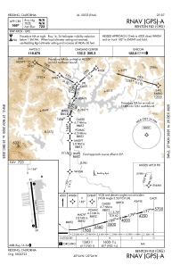
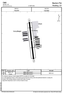


O85 - Benton Fld
Located in Redding, United States
ICAO - O85, IATA - BZF
Data provided by AirmateGeneral information
Coordinates: N40°34'25" W122°24'26"
Elevation is 723 feet MSL.
Magnetic variation is 17° East View others Airports in California
Operational data
Special qualification required
Current time UTC:
Current local time:
Weather at : KRDD - Redding Rgnl ( 12 km )
METAR: KRDD 192253Z 14006KT 10SM CLR 28/12 A2985 RMK AO2 SLP103 T02780117
TAF: KRDD 192326Z 2000/2024 VRB05KT P6SM SCT250
Communications frequencies: [VIEW]
Runways:
| RWY identifier | QFU | Length (ft) | Width (ft) | Surface | LDA (ft) |
| 15 | 0° | 2420 | 75 | ASPH | |
| 33 | 0° | 2420 | 75 | ASPH |
Airport contact information
Address: Redding United States
