


O53 - Medford Muni
Located in Medford, United States
ICAO - O53, IATA -
Data provided by AirmateGeneral information
Coordinates: N36°47'26" W97°44'56"
Elevation is 1092 feet MSL.
Magnetic variation is 05° East View others Airports in Oklahoma
Operational data
Special qualification required
Current time UTC:
Current local time:
Weather at : KBKN - Blackwell-Tonkawa Muni ( 36 km )
METAR: KBKN 252215Z AUTO 15013G20KT BKN070 BKN080 27/18 A2973 RMK AO2
Communications frequencies: [VIEW]
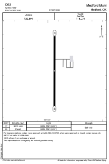
Runways:
| RWY identifier | QFU | Length (ft) | Width (ft) | Surface | LDA (ft) |
| 17 | 180° | 3007 | 60 | ASPH | |
| 35 | 360° | 3007 | 60 | ASPH |
Airport contact information
Address: Medford United States