


NZWO - Wairoa
Located in Wairoa, New Zealand
ICAO - NZWO, IATA - WIR
Data provided by AirmateGeneral information
Coordinates: S39°0'55" E177°24'15"
Elevation is 42 feet MSL.
Magnetic variation is +21° East View others Airports in Hawke's Bay Region
Operational data
Special qualification required
Current time UTC:
Current local time:
Communications frequencies: [VIEW]
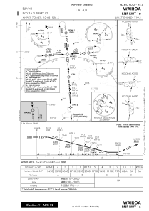
Runways:
| RWY identifier | QFU | Length (ft) | Width (ft) | Surface | LDA (ft) |
| 16 | 175° | 4498 | 299 | ASP+GRS | 2999 |
| 34 | 355° | 2999 | 98 | BITUM | 2999 |
| 34 GR-B | 0° | 4498 | 299 | ASP+GRS | |
| 16G | 177° | 0 | 0 | UNK | 4498 |
| 34G | 357° | 0 | 0 | UNK | 4498 |
Airport contact information
Address: Wairoa New Zealand