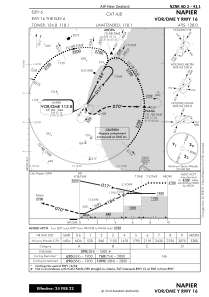


NZNR - Napier
Located in Napier, New Zealand
ICAO - NZNR, IATA - NPE
Data provided by AirmateGeneral information
Coordinates: S39°27'57" E176°52'12"
Elevation is 6 feet MSL.
Magnetic variation is +22° East View others Airports in Hawke's Bay Region
Operational data
Special qualification required
Current time UTC:
Current local time:
Weather at : - ( 0 km )
METAR: YBCS 232047Z AUTO 17009KT 9999 -RA SCT010 SCT025 BKN039 24/23 Q1013 RERA
Communications frequencies: [VIEW]
Runways:
| RWY identifier | QFU | Length (ft) | Width (ft) | Surface | LDA (ft) |
| 07 | 89° | 3934 | 98 | ASP+GRS | 3934 |
| 25 | 269° | 3934 | 98 | ASP+GRS | 3934 |
| 16 | 0° | 2513 | 115 | GRASS | 5741 |
| 34 | 0° | 5741 | 148 | BITUM | 5741 |
| 34 GR | 0° | 2513 | 115 | GRASS | |
| 34G | 0° | 0 | 0 | UNK | 2513 |
| 16G | 0° | 0 | 0 | UNK | 2513 |
Airport contact information
Address: Napier New Zealand
Other aviation service providers
Flight schools

Shoreline Helicopters Limited
Shoreline Helicopters Limited
admin@shorelinehelicopters.co.nz+6468366798