


NTHE - Ahe
Located in Tenukupara, French Polynesia
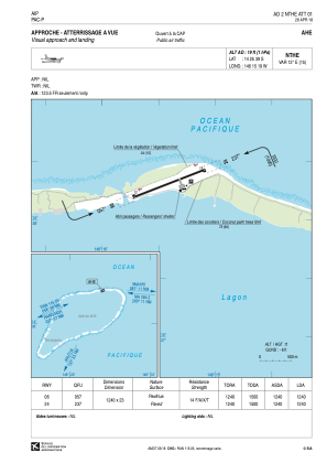
ICAO - NTHE, IATA - AHE
Data provided by AirmateGeneral information
Coordinates: S14°25'39" W146°15'19"
Elevation is 19 feet MSL.
Magnetic variation is 12.04° East View others Airports in (unassigned)
Operational data
Special qualification required
Current time UTC:
Current local time:
Weather at : - ( 0 km )
METAR: KSWF 240445Z VRB04KT 10SM BKN070 10/00 A2993
Communications frequencies: [VIEW]
Runways:
| RWY identifier | QFU | Length (ft) | Width (ft) | Surface | LDA (ft) |
| 06 | 69° | 4068 | 75 | ASPH | 4068 |
| 24 | 249° | 4068 | 75 | ASPH | 4068 |
Airport contact information
Address: Tenukupara French Polynesia