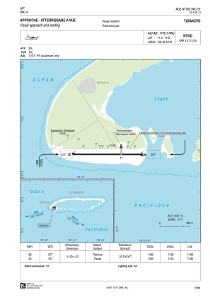


NTGO - Tatakoto
Located in , French Polynesia
ICAO - NTGO, IATA - TKV
Data provided by AirmateGeneral information
Coordinates: S17°21'19" W138°26'42"
Elevation is 17 feet MSL.
Magnetic variation is 12.70° East View others Airports in (unassigned)
Operational data
Special qualification required
Current time UTC:
Current local time:
Communications frequencies: [VIEW]
Runways:
| RWY identifier | QFU | Length (ft) | Width (ft) | Surface | LDA (ft) |
| 08 | 90° | 3904 | 75 | ASPH | 3904 |
| 26 | 270° | 3904 | 75 | ASPH | 3904 |
Airport contact information
Address: French Polynesia