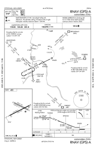
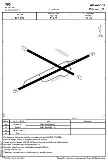


N85 - Alexandria
Located in Pittstown, United States
ICAO - N85, IATA -
Data provided by AirmateGeneral information
Coordinates: N40°35'15" W75°1'10"
Elevation is 480 feet MSL.
Magnetic variation is -10° East View others Airports in New Jersey
Operational data
Special qualification required
Current time UTC:
Current local time:
Weather at : KDYL - Doylestown ( 30 km )
METAR: KDYL 191954Z AUTO VRB03KT 10SM OVC022 13/08 A3005 RMK AO2 SLP178 T01280078
Communications frequencies: [VIEW]
Runways:
| RWY identifier | QFU | Length (ft) | Width (ft) | Surface | LDA (ft) |
| 08 | 64° | 2550 | 60 | ASPH | |
| 26 | 244° | 2550 | 60 | ASPH | |
| 13 | 118° | 1804 | 100 | OTHER | |
| 31 | 298° | 1804 | 100 | OTHER |
Airport contact information
Address: Pittstown United States
