


N69 - Stormville
Located in Stormville, United States
ICAO - N69, IATA -
Data provided by AirmateGeneral information
Coordinates: N41°34'37" W73°43'56"
Elevation is 358 feet MSL.
Magnetic variation is -12° East View others Airports in New York
Operational data
Special qualification required
Current time UTC:
Current local time:
Weather at : KPOU - Hudson Valley Rgnl ( 14 km )
METAR: KPOU 192053Z 19007KT 10SM OVC034 13/06 A3003 RMK AO2 SLP166 T01330061 56013
TAF: KPOU 191726Z 1918/2018 14009KT P6SM BKN035 OVC150 FM200300 16005KT 6SM -SHRA BR BKN025 OVC035 FM200600 VRB03KT 5SM -SHRA BR BKN015 OVC025 FM201200 29004KT P6SM OVC040 FM201500 29010G17KT P6SM SCT040 OVC100
Communications frequencies: [VIEW]
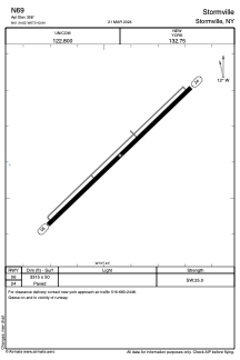
Runways:
| RWY identifier | QFU | Length (ft) | Width (ft) | Surface | LDA (ft) |
| 06 | 46° | 3315 | 50 | ASPH | |
| 24 | 226° | 3315 | 50 | ASPH |
Airport contact information
Address: Stormville United States