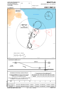
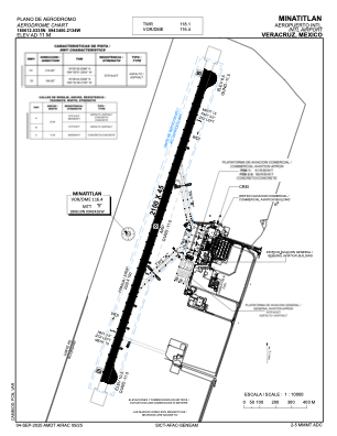


MMMT - Minatitlan Aeropuerto Internacional
Located in Minatitlan, Mexico
ICAO - MMMT, IATA - MTT
Data provided by AirmateGeneral information
Coordinates: N18°6'12" W94°34'50"
Elevation is 36 feet MSL.
View others Airports in Veracruz
Operational data
Special qualification required
Current time UTC:
Current local time:
Weather
METAR: MMMT 182040Z 36015KT 5SM SKC 28/26 A2977 RMK SLP081 57023 913 HZY
TAF: TAF MMMT 181615Z 1818/1918 02010KT 6SM HZ SCT020 BECMG 1819/1820 01015KT FM190300 36010KT 5SM HZ SCT010 BECMG 1909/1910 3SM BR HZ FM191400 06006KT 5SM HZ SKC
Communications frequencies: [VIEW]
Runways:
| RWY identifier | QFU | Length (ft) | Width (ft) | Surface | LDA (ft) |
| 01 | 18° | 6890 | 148 | ASP | |
| 19 | 198° | 6890 | 148 | ASP |
Airport contact information
Address: Minatitlan Mexico