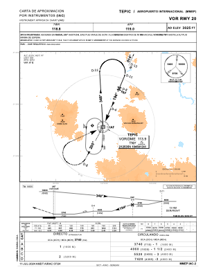
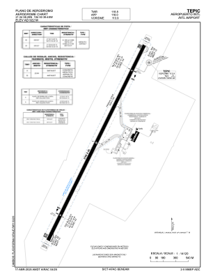


MMEP - Tepic Aeropuerto Internacional
Located in Tepic, Mexico
ICAO - MMEP, IATA - TPQ
Data provided by AirmateGeneral information
Coordinates: N21°25'10" W104°50'33"
Elevation is 3020 feet MSL.
View others Airports in Nayarit
Operational data
Special qualification required
Current time UTC:
Current local time:
Weather
METAR: MMEP 240242Z 36007KT 6SM SKC 23/13 A3007 RMK SLP161 52012 912
TAF: TAF MMEP 231731Z 2318/2418 31005KT P6SM SKC FM232100 35015KT P6SM SKC FM240300 00000KT P6SM SCT200
Communications frequencies: [VIEW]
Runways:
| RWY identifier | QFU | Length (ft) | Width (ft) | Surface | LDA (ft) |
| 02 | 26° | 7546 | 148 | ASP | |
| 20 | 206° | 7546 | 148 | ASP |
Airport contact information
Address: Tepic Mexico