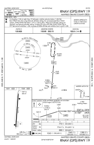


M25 - Mayfield Graves County
Located in Mayfield, United States
ICAO - M25, IATA -
Data provided by AirmateGeneral information
Coordinates: N36°46'11" W88°35'5"
Elevation is 522 feet MSL.
Magnetic variation is -02° East View others Airports in Kentucky
Operational data
Special qualification required
Current time UTC:
Current local time:
Weather at : KCEY - Kyle-Oakley Fld ( 22 km )
METAR: KCEY 160855Z AUTO 00000KT 10SM FEW037 BKN075 OVC120 20/19 A2995 RMK A01
Communications frequencies: [VIEW]
Runways:
| RWY identifier | QFU | Length (ft) | Width (ft) | Surface | LDA (ft) |
| 01 | 4° | 5002 | 100 | ASPH | |
| 19 | 184° | 5002 | 100 | ASPH |
Airport contact information
Address: Mayfield United States
