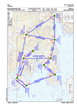
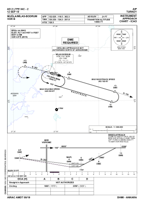


LTFE - Milas Bodrum
Located in Milas Bodrum, Turkey
ICAO - LTFE, IATA - BJV
Data provided by AirmateGeneral information
Coordinates: N37°14'58" E27°39'53"
Elevation is 21 feet MSL.
Magnetic variation is 4.9° East View others Airports in Mugla
Operational data
Special qualification required
Current time UTC:
Current local time:
Weather
METAR: LTFE 191350Z 21010KT 9999 FEW035 SCT100 BKN200 22/11 Q1009 NOSIG RMK RWY10 17008KT 140V200
TAF: TAF COR LTFE 191040Z 1912/2012 22012KT 9999 SCT035 BKN100 BECMG 1915/1917 VRB02KT BECMG 1919/1922 12012KT -SHRA BECMG 1923/2002 14025G40KT -TSRA FEW020CB BKN030 TEMPO 2002/2006 23025G35KT 1500 +TSRA BKN012CB BECMG 2005/2006 22012KT -SHRA PROB40 TEMPO 2007/2011 4000 TSRA
Communications frequencies: [VIEW]
Runways:
| RWY identifier | QFU | Length (ft) | Width (ft) | Surface | LDA (ft) |
| 10L | 107° | 9843 | 148 | CONC | 9843 |
| 28R | 287° | 9843 | 148 | CONC | 9843 |
| 10R | 106° | 9646 | 148 | CONC | 9646 |
| 28L | 286° | 9646 | 148 | CONC | 8202 |
Airport contact information
Address: Milas Bodrum Turkey