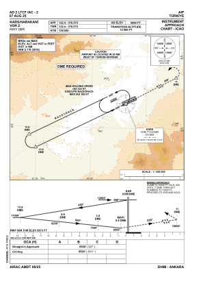
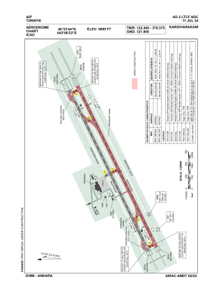


LTCF - Kars Harakani
Located in Kars, Turkey
ICAO - LTCF, IATA - KSY
Data provided by AirmateGeneral information
Coordinates: N40°33'44" E43°6'53"
Elevation is 5889 feet MSL.
Magnetic variation is 6.2° East View others Airports in Kars
Operational data
Special qualification required
Current time UTC:
Current local time:
Weather
METAR: LTCF 240050Z VRB01KT CAVOK M01/M05 Q1025 NOSIG
TAF: TAF LTCF 232240Z 2400/2409 VRB02KT CAVOK
Communications frequencies: [VIEW]
Runways:
| RWY identifier | QFU | Length (ft) | Width (ft) | Surface | LDA (ft) |
| 06L | 65° | 11483 | 148 | ASPH | 11483 |
| 24R | 245° | 11483 | 148 | ASPH | 11483 |
| 06R | 65° | 11483 | 148 | ASPH | 11483 |
| 24L | 245° | 11483 | 148 | ASPH | 11483 |
Airport contact information
Address: Kars Turkey