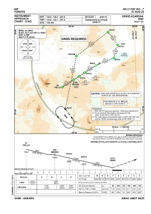
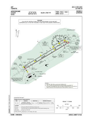


LTAY - Denizli Cardak
Located in Denizli, Turkey
ICAO - LTAY, IATA - DNZ
Data provided by AirmateGeneral information
Coordinates: N37°47'16" E29°42'18"
Elevation is 2794 feet MSL.
Magnetic variation is 5.1° East View others Airports in Denizli
Operational data
Special qualification required
Current time UTC:
Current local time:
Weather
METAR: LTAY 200750Z VRB02KT 9999 FEW030CB BKN035 BKN090 09/07 Q1006 RESHRA BECMG 25015KT
TAF: TAF LTAY 200440Z 2006/2106 15015G25KT 9999 -SHRA SCT035 BKN100 TEMPO 2006/2008 VRB20G35KT 2500 +TSRA SCT020CB BKN030 BECMG 2008/2010 25015KT TEMPO 2012/2016 -TSRA FEW020CB BKN030 PROB30 TEMPO 2016/2018 -TSRA FEW020CB BKN030 BECMG 2018/2021 VRB02KT PROB40 TEMPO 2102/2106 1200 BCFG BKN005
Communications frequencies: [VIEW]
Runways:
| RWY identifier | QFU | Length (ft) | Width (ft) | Surface | LDA (ft) |
| 05 | 59° | 9843 | 148 | ASPH | 9843 |
| 23 | 239° | 9843 | 148 | ASPH | 9843 |
Airport contact information
Address: Denizli Turkey