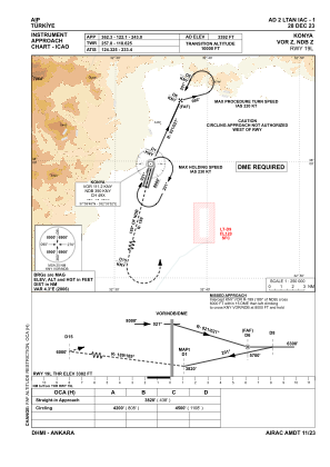
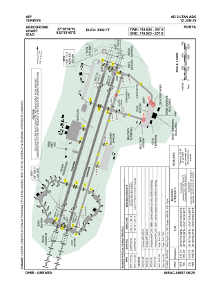


LTAN - Konya
Located in Konya, Turkey
ICAO - LTAN, IATA - KYA
Data provided by AirmateGeneral information
Coordinates: N37°58'50" E32°33'45"
Elevation is 3392 feet MSL.
Magnetic variation is 5.3° East View others Airports in Konya
Operational data
Special qualification required
Current time UTC:
Current local time:
Weather
METAR: LTAN 161950Z 17006KT CAVOK 17/M02 Q1016 NOSIG
TAF: TAF LTAN 161940Z 1621/1706 21006KT CAVOK
Communications frequencies: [VIEW]
Runways:
| RWY identifier | QFU | Length (ft) | Width (ft) | Surface | LDA (ft) |
| 01R | 17° | 10984 | 148 | CONC | 10984 |
| 19L | 197° | 10984 | 148 | CONC | 10984 |
| 01L | 17° | 10984 | 148 | CONC+ASPH | 10984 |
| 19R | 197° | 10984 | 148 | CONC+ASPH | 10984 |
Airport contact information
Address: Konya Turkey