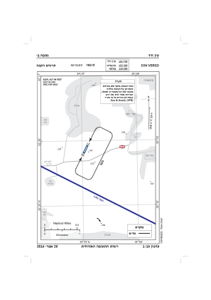
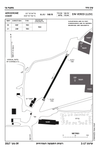


LLEV - Ein Vered
Located in Ein Vered, Israel
ICAO - , IATA -
Data provided by AirmateGeneral information
Coordinates: N32°15'54" E34°57'6"
Elevation is 193 feet MSL.
Magnetic variation is 5° East View others Airports in Tel Aviv District
Operational data
Special qualification required
Current time UTC:
Current local time:
Weather at : LLHZ - Herzelia Domestic Airport ( 14 km )
TAF: TAF LLHZ 191103Z 1912/2012 32010KT 9999 SCT025 BECMG 1915/1917 VRB03KT SCT020 PROB40 TEMPO 1922/2006 15005KT 8000 BKN015 BECMG 2008/2010 30010KT CAVOK TX23/1912Z TN15/2003Z
Communications frequencies: [VIEW]
Runways:
| RWY identifier | QFU | Length (ft) | Width (ft) | Surface | LDA (ft) |
| 02 | 28° | 637 | 26 | DIRT | |
| 20 | 208° | 637 | 26 | DIRT |
Airport contact information
Address: Ein Vered Israel