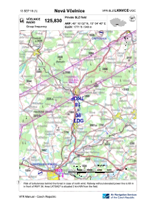


LKNVCE - Nova Vcelnice
Located in Nová Včelnice, Czech Republic
ICAO - , IATA -
Data provided by AirmateGeneral information
Coordinates: N49°16'2" E15°4'40"
Elevation is 1771 feet MSL.
View others Airports in South Bohemian Region
Operational data
Special qualification required
Current time UTC:
Current local time:
Weather at : LKNA - Namest ( 77 km )
METAR: LKNA 201200Z 34009KT 9999 -SHRA BKN021 BKN045 06/03 Q1010 NOSIG RMK WHT WHT
TAF: TAF LKNA 201100Z 2012/2112 33014KT 9999 BKN025 BKN050 TEMPO 2012/2020 35015G25KT 7000 SHRA BKN020 PROB30 TEMPO 2013/2019 5000 -RA BKN013 BECMG 2020/2022 35007KT 9999 SCT030 BKN050 TEMPO 2107/2112 02011KT 9999 BKN025
Communications frequencies: [VIEW]
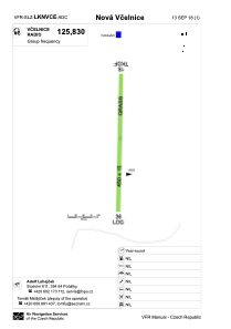
Runways:
| RWY identifier | QFU | Length (ft) | Width (ft) | Surface | LDA (ft) |
| 18 | 1° | 1476 | 49 | GRASS | |
| 36 | 181° | 1476 | 49 | GRASS | 1476 |
Airport contact information
Address: Nová Včelnice Czech Republic