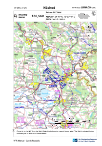


LKNACH - Nachod
Located in Náchod, Czech Republic
ICAO - , IATA -
Data provided by AirmateGeneral information
Coordinates: N50°24'47" E16°7'18"
Elevation is 1443 feet MSL.
View others Airports in Hradec Králové Region
Operational data
Special qualification required
Current time UTC:
Current local time:
Weather at : LKPD - Pardubice ( 52 km )
METAR: LKPD 250530Z 23004KT CAVOK 04/M00 Q1006 NOSIG RMK BLU BLU
TAF: TAF LKPD 242300Z 2500/2600 24008KT CAVOK PROB30 TEMPO 2500/2505 SCT020 TEMPO 2507/2518 24014KT 7000 SHRA BKN030 PROB30 TEMPO 2509/2518 26015G25KT 5000 SHRA BKN025TCU
Communications frequencies: [VIEW]
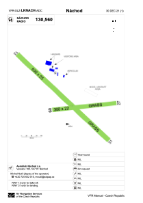
Runways:
| RWY identifier | QFU | Length (ft) | Width (ft) | Surface | LDA (ft) |
| 09 | 84° | 1181 | 72 | GRASS | 1181 |
| 27 | 264° | 1181 | 72 | GRASS | 1181 |
| 13 | 134° | 2067 | 82 | GRASS | |
| 31 | 314° | 2067 | 82 | GRASS | 2067 |
Airport contact information
Address: Náchod Czech Republic