


LKKEJZ - Kejzlice
Located in Kejžlice, Czech Republic
ICAO - , IATA -
Data provided by AirmateGeneral information
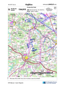
Coordinates: N49°35'32" E15°24'5"
Elevation is 1594 feet MSL.
View others Airports in Vysocina Region
Operational data
Special qualification required
Current time UTC:
Current local time:
Weather at : LKCV - Caslav ( 39 km )
METAR: LKCV 190830Z 22012KT CAVOK 08/02 Q1011 NOSIG RMK BLU BLU
TAF: TAF LKCV 190500Z 1906/2006 24012KT CAVOK PROB40 TEMPO 1908/1912 7000 SHRA BKN030 TEMPO 1909/1916 25016G26KT BECMG 1910/1912 BKN025 PROB40 TEMPO 1912/1915 24020G30KT TEMPO 1912/2006 5000 RA SCT014 BKN018
Communications frequencies: [VIEW]
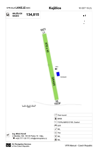
Runways:
| RWY identifier | QFU | Length (ft) | Width (ft) | Surface | LDA (ft) |
| 17 | 170° | 2198 | 131 | GRASS | 2198 |
| 35 | 350° | 2198 | 131 | GRASS |
Airport contact information
Address: Kejžlice Czech Republic