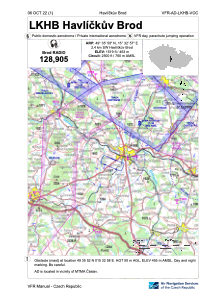
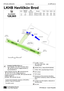


LKHB - Havlickuv Brod
Located in Havlickuv Brod, Czech Republic
ICAO - LKHB, IATA -
Data provided by AirmateGeneral information
Coordinates: N49°35'50" E15°32'57"
Elevation is 1519 feet MSL.
View others Airports in Vysocina Region
Operational data
Special qualification required
Current time UTC:
Current local time:
Weather at : LKCV - Caslav ( 40 km )
METAR: LKCV 231600Z 04003KT CAVOK 09/M03 Q1013 NOSIG RMK BLU BLU
TAF: TAF LKCV 231100Z 2312/2412 07006KT CAVOK TEMPO 2318/2401 VRB02KT BECMG 2401/2403 32005KT BECMG 2403/2405 BKN028
Communications frequencies: [VIEW]
Runways:
| RWY identifier | QFU | Length (ft) | Width (ft) | Surface | LDA (ft) |
| 11 | 0° | 2625 | 164 | GRASS | |
| 29 | 0° | 2625 | 164 | GRASS |
Airport contact information
Address: Havlickuv Brod Czech Republic