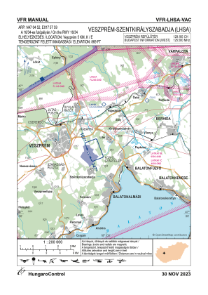
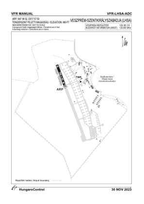


LHSA - Szentkiralyszabadja
Located in Szentkiralyszabadja, Hungary
ICAO - LHSA, IATA -
Data provided by AirmateGeneral information
Coordinates: N47°4'52" E17°57'59"
Elevation is 919 feet MSL.
View others Airports in Veszprém
Operational data
Special qualification required
Current time UTC:
Current local time:
Weather at : LHPA - Papa ( 47 km )
METAR: LHPA 230845Z 02008KT 9999 FEW015 BKN050 OVC083 07/03 Q1015 NOSIG RMK BLU
TAF: TAF LHPA 230515Z 2306/2406 06011KT 9999 BKN030 BKN080 TEMPO 2306/2315 8000 -RA SCT015 BKN025 OVC080 BECMG 2315/2318 36009KT TEMPO 2315/2406 35014KT 6000 SHRA RA SCT010 BKN025TCU BKN035
Communications frequencies: [VIEW]
Runways:
| RWY identifier | QFU | Length (ft) | Width (ft) | Surface | LDA (ft) |
| 16 | 0° | 2592 | 164 | ASPH | |
| 34 | 0° | 2592 | 164 | ASPH |
Airport contact information
Address: Szentkiralyszabadja Hungary