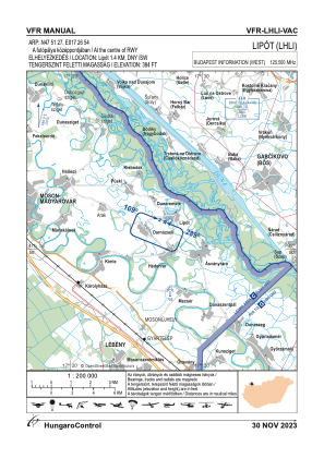
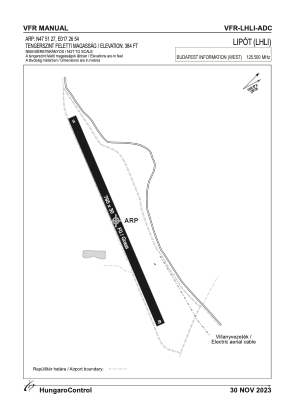


LHLI - Lipot/Szigetkoz
Located in Lipot, Hungary
ICAO - , IATA -
Data provided by AirmateGeneral information
Coordinates: N47°51'27" E17°26'54"
Elevation is 384 feet MSL.
View others Airports in Gyor-Moson-Sopron
Operational data
Special qualification required
Current time UTC:
Current local time:
Weather at : LHPR - Gyor/Per ( 37 km )
METAR: LHPR 200745Z AUTO 31014KT 280V340 9999 SCT030 10/02 Q1010 NOSIG
TAF: TAF LHPR 200815Z 2009/2018 31013KT 9999 SCT030 TEMPO 2009/2018 VRB18G30KT SHRAGS SCT030CB BKN045 PROB40 TEMPO 2010/2016 4000 TSGS
Communications frequencies: [VIEW]
Runways:
| RWY identifier | QFU | Length (ft) | Width (ft) | Surface | LDA (ft) |
| 11 | 0° | 2608 | 98 | GRASS | |
| 29 | 0° | 2608 | 98 | GRASS |
Airport contact information
Address: Lipot Hungary