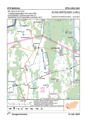
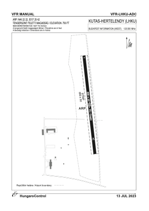


LHKU - Kutas/Hertelendy
Located in Kutas, Hungary
ICAO - , IATA -
Data provided by AirmateGeneral information
Coordinates: N46°22'22" E17°25'42"
Elevation is 469 feet MSL.
View others Airports in (unassigned)
Operational data
Special qualification required
Current time UTC:
Current local time:
Weather at : LHSM - Heviz-Balaton Airport ( 40 km )
METAR: LHSM 190945Z AUTO VRB05KT CAVOK 12/M00 Q1015 NOSIG
TAF: TAF LHSM 190815Z 1909/1918 33006KT CAVOK BECMG 1909/1912 22004KT TEMPO 1913/1917 VRB18G28KT 3000 SHRAGS SCT040CB BKN055 BKN110 BECMG 1915/1918 13005KT
Communications frequencies: [VIEW]
Runways:
| RWY identifier | QFU | Length (ft) | Width (ft) | Surface | LDA (ft) |
| 17 | 0° | 2264 | 66 | GRASS | |
| 35 | 0° | 2264 | 66 | GRASS |
Airport contact information
Address: Kutas Hungary