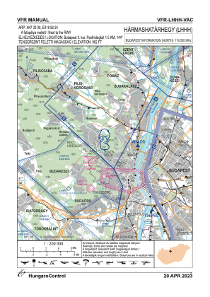
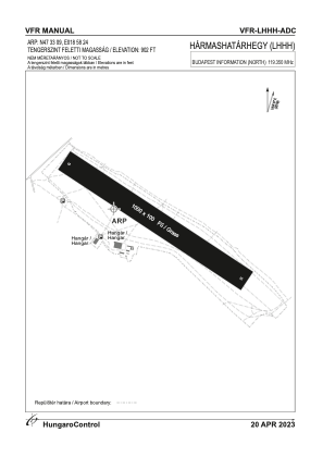


LHHH - Harmashatarhegy
Located in Budapest, Hungary
ICAO - LHHH, IATA -
Data provided by AirmateGeneral information
Coordinates: N47°33'1" E18°58'25"
Elevation is 971 feet MSL.
Magnetic variation is 5° East View others Airports in Budapest
Operational data
Special qualification required
Current time UTC:
Current local time:
Weather at : LHBP - Budapest/Liszt Ferenc International Airport ( 25 km )
METAR: LHBP 250430Z VRB01KT 9999 3000 NSC 01/01 Q1007 TEMPO TL0530 MIFG
TAF: TAF LHBP 242315Z 2500/2524 25006KT 9999 FEW020 BKN100 BECMG 2500/2503 CAVOK TEMPO 2502/2506 VRB03KT MIFG BECMG 2506/2509 31009KT SCT030 BECMG 2511/2514 CAVOK BECMG 2514/2517 31003KT
Communications frequencies: [VIEW]
Runways:
| RWY identifier | QFU | Length (ft) | Width (ft) | Surface | LDA (ft) |
| 13 | 0° | 3281 | 328 | GRASS | |
| 31 | 0° | 3281 | 328 | GRASS |
Airport contact information
Address: Budapest Hungary