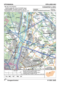
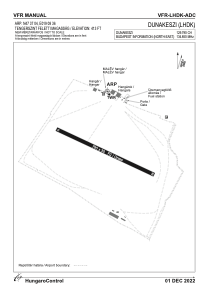


LHDK - Dunakeszi
Located in Dunakeszi, Hungary
ICAO - LHDK, IATA -
Data provided by AirmateGeneral information
Coordinates: N47°37'4" E19°8'36"
Elevation is 413 feet MSL.
Magnetic variation is 3.8° East View others Airports in Pest
Operational data
Special qualification required
Current time UTC:
Current local time:
Weather at : LHBP - Budapest/Liszt Ferenc International Airport ( 22 km )
METAR: LHBP 251230Z 26008KT 230V310 CAVOK 14/M01 Q1008 NOSIG
TAF: TAF LHBP 251115Z 2512/2612 30007KT CAVOK BECMG 2519/2522 VRB03KT BECMG 2604/2607 15008KT BKN045
Communications frequencies: [VIEW]
Runways:
| RWY identifier | QFU | Length (ft) | Width (ft) | Surface | LDA (ft) |
| 11 | 0° | 2625 | 1312 | GRASS | |
| 29 | 0° | 2625 | 1312 | GRASS |
Airport contact information
Address: Dunakeszi Hungary