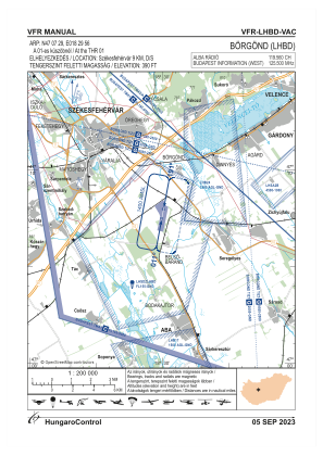
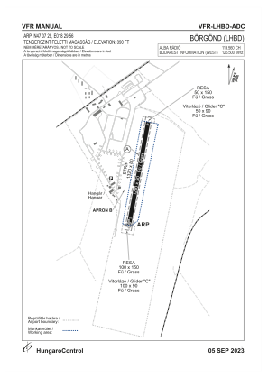


LHBD - Borgond/Alba Airport
Located in Borgond, Hungary
ICAO - , IATA -
Data provided by AirmateGeneral information
Coordinates: N47°7'48" E18°30'1"
Elevation is 404 feet MSL.
Magnetic variation is 5° East View others Airports in Fejér
Operational data
Special qualification required
Current time UTC:
Current local time:
Weather at : LHBP - Budapest/Liszt Ferenc International Airport ( 67 km )
METAR: LHBP 252330Z 33001KT CAVOK 02/01 Q1011 NOSIG
TAF: TAF LHBP 252315Z 2600/2624 VRB03KT CAVOK TEMPO 2600/2605 MIFG TEMPO 2603/2606 SCT045 BECMG 2606/2609 15009KT BKN045 TEMPO 2609/2616 VRB12G22KT -SHRA SCT040TCU BKN050 BECMG 2616/2619 11005KT CAVOK
Communications frequencies: [VIEW]
Runways:
| RWY identifier | QFU | Length (ft) | Width (ft) | Surface | LDA (ft) |
| 01 | 0° | 3937 | 164 | GRASS | |
| 19 | 0° | 3937 | 164 | GRASS |
Airport contact information
Address: Borgond Hungary