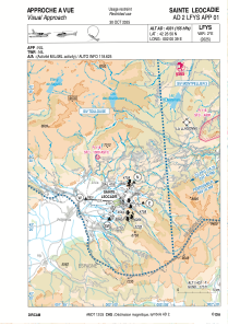


LFYS - Sainte Leocadie
Located in , France
ICAO - LFYS, IATA -
Data provided by AirmateGeneral information
Coordinates: N42°26'50" E2°0'39"
Elevation is 4331 feet MSL.
Magnetic variation is 1.16° East View others Airports in Languedoc-Roussillon
Operational data
Special qualification required
Current time UTC:
Current local time:
Weather at : LESU - Andorra-La Seu D'urgell ( 51 km )
TAF: TAF LESU 181400Z 1815/1915 31009KT 9999 FEW040 TX22/1914Z TNM03/1904Z PROB40 TEMPO 1815/1817 31015G25KT BECMG 1818/1820 VRB03KT
Communications frequencies: [VIEW]
Runways:
| RWY identifier | QFU | Length (ft) | Width (ft) | Surface | LDA (ft) |
| 07 | 70° | 2625 | 295 | GRASS | |
| 25 | 250° | 2625 | 295 | GRASS |
Airport contact information
Address: France
