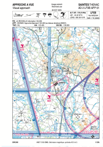


LFXB - Saintes Thenac
Located in Saintes, France
ICAO - LFXB, IATA - XST
Data provided by AirmateGeneral information
Coordinates: N45°42'7" W0°38'10"
Elevation is 118 feet MSL.
Magnetic variation is 0.31° East View others Airports in Poitou-Charentes
Operational data
Special qualification required
Current time UTC:
Current local time:
Weather at : LFBG - Cognac Chateaubernard ( 25 km )
METAR: LFBG 190400Z AUTO 00000KT CAVOK 03/01 Q1024
TAF: TAF LFBG 182000Z 1821/1921 VRB03KT CAVOK BECMG 1913/1915 30010KT
Communications frequencies: [VIEW]
Runways:
| RWY identifier | QFU | Length (ft) | Width (ft) | Surface | LDA (ft) |
| 05L | 52° | 2953 | 262 | GRASS | |
| 23R | 232° | 2953 | 262 | GRASS | |
| 05R | 52° | 2953 | 164 | GRASS | |
| 23L | 232° | 2953 | 164 | GRASS | |
| 12 | 120° | 2625 | 328 | GRASS | |
| 30 | 300° | 2625 | 328 | GRASS | |
| 05 | 52° | 3609 | 148 | ASPH | 3281 |
| 23 | 232° | 3609 | 148 | ASPH | 3281 |
Airport contact information
Address: Saintes France


