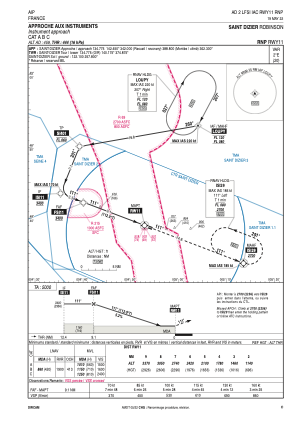
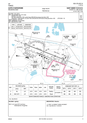


LFSI - Saint Dizier Robinson
Located in Saint-Dizier, France
ICAO - LFSI, IATA -
Data provided by AirmateGeneral information
Coordinates: N48°38'1" E4°54'29"
Elevation is 459 feet MSL.
Magnetic variation is 1.78° East View others Airports in Champagne-Ardenne
Operational data
Special qualification required
Current time UTC:
Current local time:
Weather
METAR: LFSI 190300Z AUTO 22008KT CAVOK 06/03 Q1020
TAF: TAF LFSI 182000Z 1821/1921 VRB03KT CAVOK BECMG 1909/1911 BKN012 TEMPO 1915/1918 2000 SHRA BKN020TCU
Communications frequencies: [VIEW]
Runways:
| RWY identifier | QFU | Length (ft) | Width (ft) | Surface | LDA (ft) |
| 11L | 113° | 3937 | 328 | GRASS | |
| 29R | 293° | 3937 | 328 | GRASS | |
| 11 | 113° | 7917 | 148 | ASPH | 7917 |
| 29 | 293° | 7917 | 148 | ASPH | 7917 |
Airport contact information
Address: Saint-Dizier France
Other aviation service providers
Aviation club (not for profit)

Aéroclub de Saint Dizier Robinson
Aéroclub de Saint Dizier Robinson
aero-clubstdizier@free.fr+33325050467
