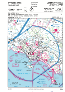

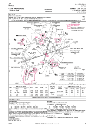


LFRH - Lorient Lann Bihoue
Located in Qu, France
ICAO - LFRH, IATA - LRT
Data provided by AirmateGeneral information
Coordinates: N47°45'38" W3°26'24"
Elevation is 159 feet MSL.
Magnetic variation is -0.73° East View others Airports in Brittany
Operational data
Special qualification required
Current time UTC:
Current local time:
Weather
METAR: LFRH 250000Z AUTO 02002KT 9999 FEW037 OVC062 07/06 Q1013 NOSIG
TAF: TAF LFRH 242300Z 2500/2524 VRB05KT 9999 SCT020 BKN040 BECMG 2512/2514 26010KT TEMPO 2518/2524 4000 SHRA BKN008CB BKN010
Communications frequencies: [VIEW]
Runways:
| RWY identifier | QFU | Length (ft) | Width (ft) | Surface | LDA (ft) |
| 02 | 16° | 5479 | 148 | CONC | 5479 |
| 20 | 196° | 5479 | 148 | CONC | 5479 |
| 07 | 72° | 7884 | 148 | CONC | 7884 |
| 25 | 252° | 7884 | 148 | CONC | 7316 |
Airport contact information
Address: Qu France


