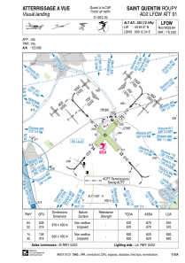


LFOW - Saint Quentin Roupy
Located in Saint Quentin, France
ICAO - LFOW, IATA -
Data provided by AirmateGeneral information
Coordinates: N49°49'1" E3°12'24"
Elevation is 325 feet MSL.
Magnetic variation is 1.24° East View others Airports in Picardie
Operational data
Special qualification required
Current time UTC:
Current local time:
Communications frequencies: [VIEW]
Runways:
| RWY identifier | QFU | Length (ft) | Width (ft) | Surface | LDA (ft) |
| 04 | 41° | 2198 | 328 | GRASS | 2198 |
| 22 | 221° | 2198 | 328 | GRASS | 1870 |
| 14 | 138° | 2034 | 328 | GRASS | 2034 |
| 32 | 318° | 2034 | 328 | GRASS | 2034 |
Airport contact information
Address: Saint Quentin France
Other aviation service providers
Aviation club (not for profit)

Aéroclub Saint Quentin-Picardie
Aéroclub Saint Quentin-Picardie
aeroclubstquentin@orange.fr+33323620000