
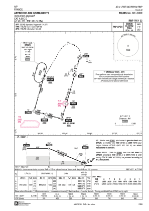
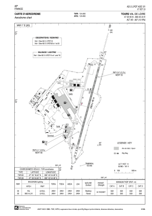


LFOT - Tours Val De Loire
Located in Tours, France
ICAO - LFOT, IATA - TUF
Data provided by AirmateGeneral information
Coordinates: N47°25'55" E0°43'23"
Elevation is 357 feet MSL.
Magnetic variation is 0.61° East View others Airports in Centre
Operational data
Special qualification required
Current time UTC:
Current local time:
Weather
TAF: TAF LFOT 191116Z 1912/2012 28011KT 9999 SCT040 SCT055 TEMPO 1912/1914 29015G25KT PROB40 TEMPO 1920/1923 34010KT -SHRA BECMG 1923/2001 02009KT
Communications frequencies: [VIEW]
Runways:
| RWY identifier | QFU | Length (ft) | Width (ft) | Surface | LDA (ft) |
| 02 | 15° | 7887 | 148 | CONC | 7887 |
| 20 | 195° | 7887 | 148 | CONC | 7887 |
Airport contact information
Address: Tours France


