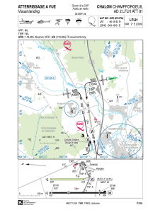
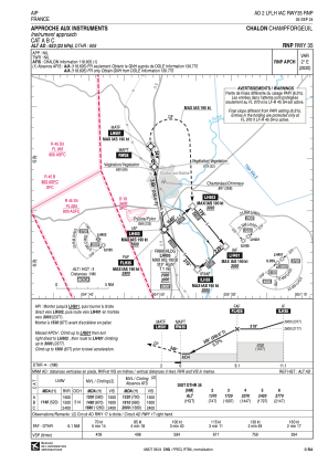
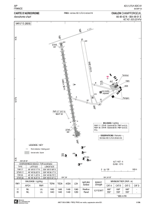


LFLH - Chalon Champforgeuil
Located in Chalon-Sur-Saone, France
ICAO - LFLH, IATA - XCD
Data provided by AirmateGeneral information
Coordinates: N46°49'42" E4°49'1"
Elevation is 623 feet MSL.
Magnetic variation is 1.80° East View others Airports in Burgundy
Operational data
Special qualification required
Current time UTC:
Current local time:
Weather at : LFGJ - Dole Tavaux ( 53 km )
METAR: LFGJ 190300Z AUTO 15003KT 3600 1600 BR NSC M00/M00 Q1022
Communications frequencies: [VIEW]
Runways:
| RWY identifier | QFU | Length (ft) | Width (ft) | Surface | LDA (ft) |
| 17L | 170° | 2785 | 164 | GRASS | 2785 |
| 35R | 350° | 2785 | 164 | GRASS | 2785 |
| 17 | 171° | 4724 | 98 | ASPH | 4528 |
| 35 | 351° | 4724 | 98 | ASPH | 4199 |
Airport contact information
Address: Chalon-Sur-Saone France
Handlers

Other aviation service providers
Aviation club (not for profit)

Club Rsa Ass Des Amateurs D'aéronefs Bourgogne
Club Rsa Ass Des Amateurs D'aéronefs Bourgogne
acgrandchalon@hotmail.fr0670725531