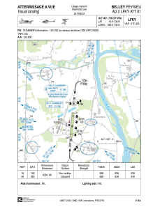


LFKY - Belley-Peyrieu
Located in , France
ICAO - LFKY, IATA -
Data provided by AirmateGeneral information
Coordinates: N45°41'38" E5°41'30"
Elevation is 739 feet MSL.
Magnetic variation is 2.04° East View others Airports in Rhône Alpes
Operational data
Special qualification required
Current time UTC:
Current local time:
Weather at : LFLB - Chambery Aix Les Bains ( 16 km )
METAR: LFLB 251600Z AUTO 35006KT 9999 FEW080 14/M00 Q1006 NOSIG
TAF: TAF LFLB 251400Z 2515/2615 36006KT CAVOK BECMG 2518/2520 18006KT TEMPO 2520/2609 FEW060TCU PROB30 TEMPO 2604/2610 36005KT -SHRA SCT060TCU TEMPO 2610/2614 RA FEW040TCU OVC050
Communications frequencies: [VIEW]
Runways:
| RWY identifier | QFU | Length (ft) | Width (ft) | Surface | LDA (ft) |
| 18 | 185° | 2093 | 197 | GRASS | 1768 |
| 36 | 5° | 2093 | 197 | GRASS | 1772 |
Airport contact information
Address: France
Other aviation service providers
Aviation club (not for profit)

Aéroclub de Belley-Peyrieu
Aéroclub de Belley-Peyrieu
secretaire@aeroclub-belleypeyrieu.fr+33479420019