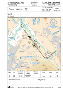


LFKE - Saint Jean En Royans
Located in , France
ICAO - LFKE, IATA -
Data provided by AirmateGeneral information
Coordinates: N45°1'35" E5°18'33"
Elevation is 872 feet MSL.
Magnetic variation is 1.95° East View others Airports in Rhône Alpes
Operational data
Special qualification required
Current time UTC:
Current local time:
Weather at : LFLU - Valence Chabeuil ( 29 km )
METAR: LFLU 191800Z AUTO 02006KT CAVOK 14/00 Q1017
Communications frequencies: [VIEW]
Runways:
| RWY identifier | QFU | Length (ft) | Width (ft) | Surface | LDA (ft) |
| 14 | 144° | 2188 | 164 | GRASS | 1991 |
| 32 | 324° | 2188 | 164 | GRASS | 2188 |
Airport contact information
Address: France
