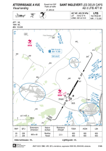


LFIS - Saint Inglevert Les Deux Caps
Located in , France
ICAO - , IATA -
Data provided by AirmateGeneral information
Coordinates: N50°52'57" E1°44'10"
Elevation is 443 feet MSL.
Magnetic variation is 0.71° East View others Airports in Nord-Pas-de-Calais
Operational data
Special qualification required
Current time UTC:
Current local time:
Weather at : LFAC - Calais Marck ( 17 km )
METAR: LFAC 252000Z AUTO 23007KT 9999 -RA FEW027/// SCT034/// BKN043/// ///CB 09/06 Q1002
Communications frequencies: [VIEW]
Runways:
| RWY identifier | QFU | Length (ft) | Width (ft) | Surface | LDA (ft) |
| 03 | 30° | 1978 | 131 | ASPH | 1978 |
| 21 | 210° | 1978 | 131 | ASPH | 1978 |
Airport contact information
Address: France

