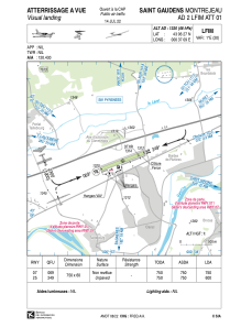


LFIM - Saint Gaudens Montrejeau
Located in Saint Gaudens, Montrejeau, France
ICAO - LFIM, IATA -
Data provided by AirmateGeneral information
Coordinates: N43°6'27" E0°37'9"
Elevation is 1320 feet MSL.
Magnetic variation is 0.78° East View others Airports in Midi-Pyrénées
Operational data
Special qualification required
Current time UTC:
Current local time:
Communications frequencies: [VIEW]
Runways:
| RWY identifier | QFU | Length (ft) | Width (ft) | Surface | LDA (ft) |
| 07 | 70° | 2461 | 197 | GRASS | 2461 |
| 25 | 250° | 2461 | 197 | GRASS | 1969 |
Airport contact information
Address: Saint Gaudens, Montrejeau France
