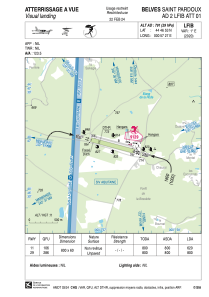


LFIB - Belves Saint Pardoux
Located in , France
ICAO - LFIB, IATA -
Data provided by AirmateGeneral information
Coordinates: N44°46'57" E0°57'32"
Elevation is 791 feet MSL.
Magnetic variation is 0.81° East View others Airports in Aquitaine
Operational data
Special qualification required
Current time UTC:
Current local time:
Weather at : LFBE - Bergerac Dordogne Perigord ( 35 km )
METAR: LFBE 251400Z AUTO VRB03KT 9999 FEW043/// BKN066/// OVC096/// //////CB 14/10 Q1007 TEMPO 3000 SHRA BKN010 BKN025TCU SCT030CB
TAF: TAF LFBE 251100Z 2512/2612 24005KT 9999 BKN030 TEMPO 2512/2520 3000 SHRA BKN010 BKN025TCU SCT030CB TEMPO 2520/2605 1500 -RA BKN005 TEMPO 2605/2612 2000 -SHRA BKN015 BKN040TCU
Communications frequencies: [VIEW]
Runways:
| RWY identifier | QFU | Length (ft) | Width (ft) | Surface | LDA (ft) |
| 11 | 108° | 2625 | 197 | GRASS | |
| 29 | 288° | 2625 | 197 | GRASS |
Airport contact information
Address: France
