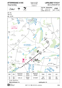


LFHX - Lapalisse Perigny
Located in Lapalisse, France
ICAO - LFHX, IATA -
Data provided by AirmateGeneral information
Coordinates: N46°15'11" E3°35'15"
Elevation is 1045 feet MSL.
Magnetic variation is 1.48° East View others Airports in Auvergne
Operational data
Special qualification required
Current time UTC:
Current local time:
Weather at : LFLV - Vichy Charmeil ( 17 km )
METAR: LFLV 191800Z AUTO 31007KT 240V350 9999 OVC058 14/04 Q1018
Communications frequencies: [VIEW]
Runways:
| RWY identifier | QFU | Length (ft) | Width (ft) | Surface | LDA (ft) |
| 05 | 51° | 3937 | 75 | ASPH | 3018 |
| 23 | 231° | 3937 | 75 | ASPH | 3937 |
Airport contact information
Address: Lapalisse France
