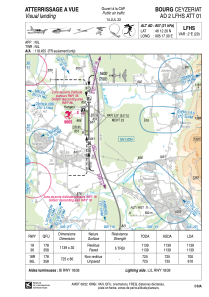


LFHS - Bourg Ceyzeriat
Located in Bourg-En-Bresse, France
ICAO - LFHS, IATA -
Data provided by AirmateGeneral information
Coordinates: N46°12'20" E5°17'30"
Elevation is 857 feet MSL.
Magnetic variation is 1.93° East View others Airports in Rhône Alpes
Operational data
Special qualification required
Current time UTC:
Current local time:
Communications frequencies: [VIEW]
Runways:
| RWY identifier | QFU | Length (ft) | Width (ft) | Surface | LDA (ft) |
| 18 | 179° | 3737 | 98 | ASPH | 3737 |
| 36 | 359° | 3737 | 98 | ASPH | 3737 |
| 18R | 180° | 2379 | 262 | GRASS | 2297 |
| 36L | 360° | 2379 | 262 | GRASS | 2001 |
Airport contact information
Address: Bourg-En-Bresse France


