


LFHL - Langogne Lesperon
Located in Langogne, France
ICAO - LFHL, IATA -
Data provided by AirmateGeneral information
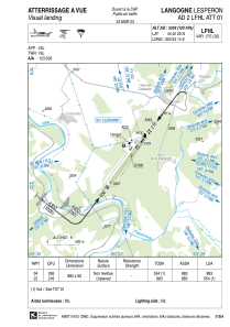
Coordinates: N44°42'20" E3°53'14"
Elevation is 3339 feet MSL.
Magnetic variation is 1.59° East View others Airports in Rhône Alpes
Operational data
Special qualification required
Current time UTC:
Current local time:
Communications frequencies: [VIEW]
Runways:
| RWY identifier | QFU | Length (ft) | Width (ft) | Surface | LDA (ft) |
| 04 | 37° | 2897 | 164 | GRASS | 2897 |
| 22 | 217° | 2897 | 164 | GRASS | 1818 |
Airport contact information
Address: Langogne France
