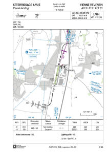


LFHH - Vienne Reventin
Located in Vienne, France
ICAO - LFHH, IATA - XVI
Data provided by AirmateGeneral information
Coordinates: N45°27'46" E4°49'40"
Elevation is 720 feet MSL.
Magnetic variation is 1.82° East View others Airports in Rhône Alpes
Operational data
Special qualification required
Current time UTC:
Current local time:
Weather at : LFLY - Lyon Bron ( 31 km )
METAR: LFLY 190630Z AUTO 19003KT CAVOK 05/03 Q1023 NOSIG
TAF: TAF LFLY 190500Z 1906/2006 VRB03KT CAVOK TEMPO 1913/1918 14006KT BECMG 1918/1920 31010KT OVC050 TEMPO 1921/2001 5000 -RA FEW020TCU OVC030 FM200100 35010KT 9999 SCT015 BKN025 PROB30 TEMPO 2001/2006 -SHRA BKN014
Communications frequencies: [VIEW]
Runways:
| RWY identifier | QFU | Length (ft) | Width (ft) | Surface | LDA (ft) |
| 01 | 12° | 2165 | 164 | GRASS | 1706 |
| 19 | 192° | 2165 | 164 | GRASS | 2165 |
Airport contact information
Address: Vienne France
