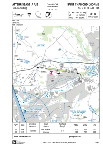


LFHG - Saint Chamond L'horme
Located in , France
ICAO - LFHG, IATA -
Data provided by AirmateGeneral information
Coordinates: N45°29'31" E4°32'4"
Elevation is 1307 feet MSL.
Magnetic variation is 1.75° East View others Airports in Rhône Alpes
Operational data
Special qualification required
Current time UTC:
Current local time:
Weather at : LFMH - Saint Etienne Loire ( 19 km )
METAR: LFMH 190100Z AUTO VRB02KT CAVOK M01/M02 Q1023
Communications frequencies: [VIEW]
Runways:
| RWY identifier | QFU | Length (ft) | Width (ft) | Surface | LDA (ft) |
| 10 | 98° | 2297 | 197 | GRASS | 2297 |
| 28 | 278° | 2297 | 197 | GRASS | 2142 |
Airport contact information
Address: France
Other aviation service providers
Aviation club (not for profit)

Aéroclub de St Chamond et de la vallée du Gier
Aéroclub de St Chamond et de la vallée du Gier
aeroclubdestchamond@orange.fr+33477220345
