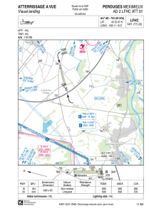


LFHC - Perouges Meximieux
Located in Perouges, France
ICAO - LFHC, IATA -
Data provided by AirmateGeneral information
Coordinates: N45°52'7" E5°11'10"
Elevation is 703 feet MSL.
Magnetic variation is 1.91° East View others Airports in Rhône Alpes
Operational data
Special qualification required
Current time UTC:
Current local time:
Communications frequencies: [VIEW]
Runways:
| RWY identifier | QFU | Length (ft) | Width (ft) | Surface | LDA (ft) |
| 16 | 165° | 2264 | 197 | GRASS | 2264 |
| 34 | 345° | 2264 | 197 | GRASS | 1870 |
Airport contact information
Address: Perouges France
