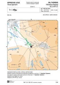


LFH31 - Val Thorens
Located in , France
ICAO - , IATA -
Data provided by AirmateGeneral information
Coordinates: N45°17'47" E6°33'56"
Elevation is 6907 feet MSL.
Magnetic variation is 2.25° East View others Airports in Rhône Alpes
Operational data
Special qualification required
Current time UTC:
Current local time:
Communications frequencies: [VIEW]
Runways:
Airport contact information
Address: France