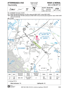


LFGN - Paray Le Monial
Located in Paray Le Monial, France
ICAO - LFGN, IATA -
Data provided by AirmateGeneral information
Coordinates: N46°28'0" E4°7'59"
Elevation is 1003 feet MSL.
Magnetic variation is 1.62° East View others Airports in Burgundy
Operational data
Special qualification required
Current time UTC:
Current local time:
Weather at : LFLN - Saint Yan ( 11 km )
METAR: LFLN 250100Z AUTO 13003KT CAVOK 04/04 Q1012
TAF: TAF LFLN 241700Z 2418/2503 VRB04KT 9999 BKN030 TEMPO 2418/2421 -SHRA FEW030TCU PROB30 TEMPO 2500/2503 4000 BR
Communications frequencies: [VIEW]
Runways:
| RWY identifier | QFU | Length (ft) | Width (ft) | Surface | LDA (ft) |
| 13 | 130° | 1969 | 328 | GRASS | |
| 31 | 310° | 1969 | 328 | GRASS |
Airport contact information
Address: Paray Le Monial France

