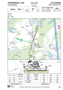


LFGI - Dijon Darois
Located in Dijon, France
ICAO - LFGI, IATA - DIJ
Data provided by AirmateGeneral information
Coordinates: N47°23'7" E4°56'49"
Elevation is 1586 feet MSL.
Magnetic variation is 1.82° East View others Airports in Burgundy
Operational data
Special qualification required
Current time UTC:
Current local time:
Weather at : LFSD - Dijon-Longvic ( 17 km )
METAR: LFSD 252300Z AUTO 18003KT CAVOK 08/04 Q1005
Communications frequencies: [VIEW]
Runways:
| RWY identifier | QFU | Length (ft) | Width (ft) | Surface | LDA (ft) |
| 02R | 19° | 2559 | 262 | GRASS | 2073 |
| 20L | 199° | 2559 | 262 | GRASS | 2559 |
| 02 | 19° | 2461 | 66 | ASPH | 2461 |
| 20 | 199° | 2461 | 66 | ASPH | 2461 |
Airport contact information
Address: Dijon France

