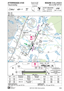


LFGF - Beaune Challanges
Located in Beaune, France
ICAO - LFGF, IATA - XBV
Data provided by AirmateGeneral information
Coordinates: N47°0'37" E4°53'47"
Elevation is 656 feet MSL.
Magnetic variation is 1.81° East View others Airports in Burgundy
Operational data
Special qualification required
Current time UTC:
Current local time:
Weather at : LFSD - Dijon-Longvic ( 32 km )
METAR: LFSD 252030Z AUTO VRB02KT CAVOK 08/04 Q1006
Communications frequencies: [VIEW]
Runways:
| RWY identifier | QFU | Length (ft) | Width (ft) | Surface | LDA (ft) |
| 02 | 26° | 2986 | 98 | ASPH | 2986 |
| 20 | 206° | 2986 | 98 | ASPH | 2986 |
| 02R | 26° | 2822 | 164 | GRASS | 2822 |
| 20L | 206° | 2822 | 164 | GRASS | 2822 |
Airport contact information
Address: Beaune France
Fuel provider

Other aviation service providers
Repair station

Aviation club (not for profit)

Aéroclub de Bourgogne
Aéroclub de Bourgogne
aeroclubdebourgogne@gmail.com+33 3 80 22 42 90
+33 6 95 22 25 28
+33 6 95 22 25 28