


LFET - Til Chatel
Located in , France
ICAO - LFET, IATA -
Data provided by AirmateGeneral information
Coordinates: N47°32'47" E5°12'39"
Elevation is 939 feet MSL.
Magnetic variation is 1.89° East View others Airports in Burgundy
Operational data
Special qualification required
Current time UTC:
Current local time:
Communications frequencies: [VIEW]
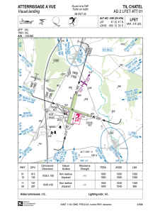
Runways:
| RWY identifier | QFU | Length (ft) | Width (ft) | Surface | LDA (ft) |
| 11 | 109° | 3412 | 197 | GRASS | 3412 |
| 29 | 289° | 3412 | 197 | GRASS | 2920 |
| 01 | 15° | 3445 | 328 | GRASS | 3445 |
| 19 | 195° | 3445 | 328 | GRASS | 3445 |
Airport contact information
Address: France
