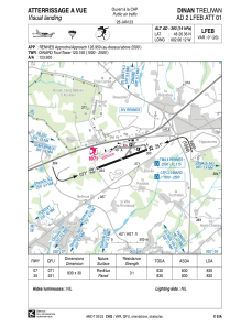


LFEB - Dinan Trelivan
Located in Dinan, France
ICAO - LFEB, IATA -
Data provided by AirmateGeneral information
Coordinates: N48°26'36" W2°6'12"
Elevation is 393 feet MSL.
Magnetic variation is -0.35° East View others Airports in Brittany
Operational data
Special qualification required
Current time UTC:
Current local time:
Weather at : LFRD - Dinard Pleurtuit Saint Malo ( 16 km )
METAR: LFRD 240130Z AUTO 20003KT 0500 R35/0600N FG FEW002 BKN056 OVC068 07/06 Q1020 TEMPO 2000 BR BKN010
TAF: TAF LFRD 232300Z 2400/2424 VRB05KT 9999 BKN030 TEMPO 2400/2409 4000 -RA BKN010 PROB40 TEMPO 2400/2406 2000 BR PROB40 TEMPO 2409/2418 4000 SHRA SCT020TCU PROB40 TEMPO 2418/2424 4000 SHRA BKN013
Communications frequencies: [VIEW]
Runways:
| RWY identifier | QFU | Length (ft) | Width (ft) | Surface | LDA (ft) |
| 07 | 70° | 2723 | 98 | ASPH | |
| 25 | 250° | 2723 | 98 | ASPH |
Airport contact information
Address: Dinan France

